Navajo Peak 13,409'
Navajo Peak and Apache Peak from the east. (A1 and 2 are routes on Apache) Photo: Rob Writz
Navajo is the beautiful and cone shaped mountain that defines the Indian Peaks. Its rugged shape symbolizes the steep walls of this wilderness area, and it is challenging to reach from all sides. The southwest side of Navajo, above Wheeler Basin, is laced with couloirs and is worth exploration. Several sticky spring upslope storms can fill those couloirs. The east and southeast sides of Navajo have large snowfields that beg for skiing, but they are shut off to all uses as they are in the Silver Lake Watershed of the City of Boulder. This area is preserved for the City of Boulder’s water supply, and no trespassing is allowed. The boundary is hard to follow, but the summit of Navajo and the routes on Navajo’s north side appear to not be in this watershed, and are accessed from the Brainard Lake area.
+ ROUTES
Approach to the tarn at 11,440'
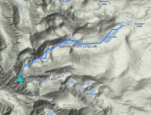
From the Long Lake Trailhead, ski or hike southwest about two tenths of a mile to Long Lake on the Pawnee Pass Trail. Follow the trail west, or the approximate path of the trail if snow covered, along the north side of Long Lake about 2 miles to Lake Isabelle. At Lake Isabelle, continue under a mile west on the north side of the Lake following the Isabelle Glacier Trail. If the lake is frozen solid it may be easier to ski across the lake, otherwise there are several steep walls on the north side of the lake that you will have to by-pass. Go about 1 mile west from the far shore of Lake Isabelle to the small tarn below Navajo, Apache, and Shoshoni Peaks at about 11,440'.
Route 1 - Navajo Snowfield
- Rating: III D10 R3
- Season: Spring, Summer
- Exposure: Northeast
- Vertical: 1,000'
- Approach Elevations: 10,080' - 13,100'
- Approach Distance: From Long Lake TH: 4.5 miles, From Brainard Lake Gateway TH: 8.5 miles
This is the permanent snowfield below the beautiful Navajo Peak. The snowfield is consistently steep and reliable. In May and June you can ski nearly 2,000' to the tarn at 11,440'. You can link snowfields to the shore of Lake Isabelle from there. Consider climbing and skiing the Navajo Snowfield in the early afternoon after a ski descent on Apache Peak. A crevasse can form on the upper north side (skier's left) side of the snowfield in late summer. The southern (skier’s right) edge of this snowfield will turn into black alpine ice by mid-summer and then this will spread across the snowfield as summer transitions into fall. Be careful of this ice, and be aware of mountaineers climbing up and down this popular route.
+ TRAILHEAD
Brainard Lake Gateway Trailhead (10,000’) and Long Lake Trailhead (10,520’)
Brainard Lake Gateway Trailhead is the access point to the Mitchell Lake and Long Lake Trailheads. The road from the Gateway Trailhead to Mitchell Lake and Long Lake may not be open to cars until mid-June. Because of this closure the spring and early summer ski adventures in the Brainard Lake area are launched from here. The spacious trailhead at the Gateway is host to a large gathering of backcountry skiers and mountaineers in the pre-dawn hours on spring weekends. When the road opens in mid-June there is an access fee into the Brainard Lake Recreation Area. Access the Brainard Lake Gateway Trailhead on Brainard Lake Drive west of the town of Ward on Highway 72.
Gear up and ski, hike or ride your bike to the Long Lake Trailhead. It is about 3.5 miles from the Gateway on the Brainard Lake Road to the right turn leading to the Mitchell Lake Trailhead and the Long Lake Trailhead. Go about one eighth of a mile up this road and turn left and go another quarter mile to Long Lake Trailhead (straight goes to the Mitchell Lake Trailhead). You can check the status of the Brainard Lake Road at the USFS Roosevelt National Forest Boulder Ranger District Road Status website.
+ MAPS & PICTURES
Below we have included a link to a Google interactive map and a curated list of photos of the mountain.
Clicking on map above will open interactive Google map website


