Shoshoni Peak 12,967'
Shoshoni Peak from the east (P1 and P2 are the routes on Pawshoni). Photo: Rob Writz
Shoshoni is one of the impressive peaks that surrounds the Isabelle Glacier and the cirque that holds Apache Peak and Navajo Peak. It is hard to see the summit from below. Shoshoni connect to Apache via a steep and a pinnacled ridge, and the south face of the mountain is near vertical. The west side of the peak drops gently at first and then numerous cliffs drop to Triangle Lake and Lone Eagle Peak. The northeast side is more moderate and is coupled with the gentle slopes of Pawshoni and Pawnee. Shoshoni has a lot to offer the ski mountaineer.
+ ROUTES
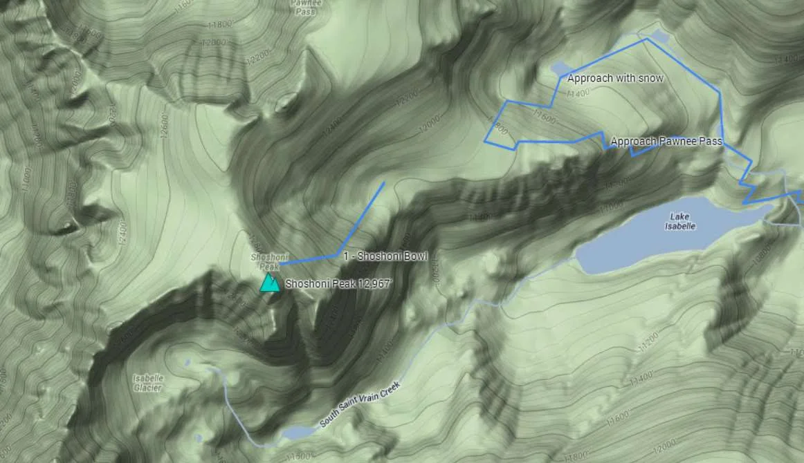
1 – Shoshoni Bowl
- Rating: II D7
- Season: Spring
- Exposure: Northeast
- Vertical: 1,100'
- Approach Elevations: 10,080' - 12,967’
- Approach Distance: From Long Lake TH: 4 miles, From Brainard Lake Gateway TH: 7 miles
The Shoshoni Bowl is the south end of a large cirque containing this route and the Pawshoni Bowl. The middle of this bowl gets melted out because of thin windswept terrain. There can be several good lines here and it is steeper than Pawshoni Bowl. The skier’s right stair steps into a wide couloir at the bottom. The upper portion of this line is in the sun early, but the wide couloir is shaded by the rock ridge of the east face. Shoshoni can easily be combined with the other routes on Pawshoni and Pawnee Peak. If you are done skiing for the day and exiting from the bottom of this route do not ski into the cirque drainage heading southeast towards Lake Isabelle. The bottom of this cirque is rocky, thin, and cliffed out. Retrace your entrance or the approximate line of Pawnee Pass Tail and stay north of the large cliffs above Lake Isabelle.
From the Long Lake Trailhead, ski or hike southwest about two tenths of a mile to Long Lake on the Pawnee Pass Trail. Ski or hike across the north side of Long Lake and then to Lake Isabelle. From the east end of Lake Isabelle, look for the approximate line of the Pawnee Pass trail switchbacking to the north. Follow this to a small tarn at 11,100'. From here you can follow the line of the Pawnee Pass Trail west through steep terrain to the bottom of the bowl at 11,800'. If the terrain is snow covered, an alternative is to continue north and northwest up the drainage just over a third of a mile to a small tarn at 11,200' and then a third mile west to the final tarn in this basin. From here you can climb southwest about 550 vertical feet to the flat area and the bottom of the bowl at 11,800'. Cross the basin and choose your line to the summit of Shoshoni Peak.
+ TRAILHEAD
Brainard Lake Gateway Trailhead (10,000’) and Long Lake Trailhead (10,520’)
Brainard Lake Gateway Trailhead is the access point to the Mitchell Lake and Long Lake Trailheads. The road from the Gateway Trailhead to Mitchell Lake and Long Lake may not be open to cars until mid-June. Because of this closure the spring and early summer ski adventures in the Brainard Lake area are launched from here. The spacious trailhead at the Gateway is host to a large gathering of backcountry skiers and mountaineers in the pre-dawn hours on spring weekends. When the road opens in mid-June there is an access fee into the Brainard Lake Recreation Area. Access the Brainard Lake Gateway Trailhead on Brainard Lake Drive west of the town of Ward on Highway 72.
Gear up and ski, hike or ride your bike to the Long Lake Trailhead. It is about 3 miles from the Gateway on the Brainard Lake Road to the right turn leading to the Mitchell Lake Trailhead and the Long Lake Trailhead. Go about one eighth of a mile up this road and turn left and go another quarter mile to Long Lake Trailhead (straight goes to the Mitchell Lake Trailhead). You can check the status of the Brainard Lake Road at the USFS Roosevelt National Forest Boulder Ranger District Road Status website. The commitment grades assume you are starting from the Brainard Lake Gateway and riding your bike in on a mostly dry road.
+ MAPS & PICTURES
Below we have included a link to a Google interactive map and a curated list of photos of the mountain.

Clicking on map above will open interactive Google map website